Exploring Wisconsin’s scenic backroads is a dream for many Jeep owners. The Trans Wisconsin Adventure Trail Jeep Map unlocks hundreds of miles of off-the-beaten-path driving, offering stunning landscapes, hidden lakes, and small-town charm. Whether you’re chasing adventure or just want a fresh drive, this route is made for those who crave something different from the usual highways. Here, you’ll find everything you need to know about the Jeep-specific experience, including map details, route highlights, planning tips, and practical advice.
What Is The Trans Wisconsin Adventure Trail?
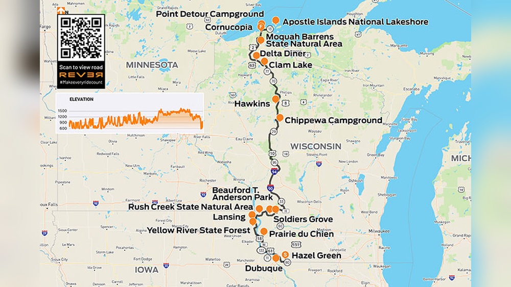
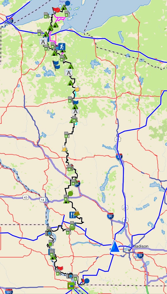
The Trans Wisconsin Adventure Trail (often called TWAT) is a long-distance, mostly unpaved route stretching across Wisconsin. Originally designed for dual-sport motorcycles, it’s become popular among Jeep and 4×4 enthusiasts because of its mix of gravel roads, forest trails, and scenic byways.
The trail starts near the Illinois-Wisconsin border and runs north to Lake Superior, covering roughly 600 miles. Most of the route is accessible to street-legal Jeeps, but some sections may be challenging or closed seasonally. The route offers a unique way to explore Wisconsin’s wild areas, historic towns, and natural beauty.
Jeep Map Overview And Route Details
The Jeep map for the Trans Wisconsin Adventure Trail is more than just a navigation tool—it’s a guide to adventure, safety, and local attractions. Digital and printed maps are available, with updated trail conditions and points of interest.
Here’s a comparison of popular map options:
| Map Type | Coverage | Features | Price |
|---|---|---|---|
| Digital GPS Map | Full TWAT route | Turn-by-turn, waypoints, offline access | $25 |
| Printed Paper Map | Full TWAT route | Easy reference, waterproof options | $15 |
| Community Map (Free) | Major sections | User-updated, basic info | $0 |
Most Jeep drivers prefer digital maps for real-time updates and GPS guidance. However, bringing a printed map as backup is smart, especially in remote areas with limited signal.

Key Route Highlights
The Trans Wisconsin Adventure Trail is rich in variety. Here are some standout sections that make it special for Jeep owners:
- Driftless Area – Rolling hills and winding gravel roads, perfect for testing your Jeep’s handling.
- Chequamegon-Nicolet National Forest – Dense woods, wildlife, and forest trails offer a true off-road experience.
- Black River State Forest – Sandy trails, water crossings, and scenic spots for photos.
- Lake Superior Shoreline – The final stretch delivers breathtaking views and a sense of accomplishment.
Along the way, you’ll pass through historic mining towns, rustic campgrounds, and family-friendly stops. Some sections are accessible year-round, while others may close during winter or spring due to mud or snow.
Planning Your Jeep Adventure
Preparation makes or breaks a successful trip. Here’s what to consider before setting out:
- Route Research: Check current trail conditions and closures. Some areas may be blocked by fallen trees or flooding.
- Vehicle Prep: Inspect tires, brakes, and suspension. Carry a spare tire and essential tools.
- Navigation: Download digital maps and carry a backup paper map.
- Supplies: Pack food, water, first aid kit, and extra fuel. Rural stretches may not have gas stations for over 50 miles.
- Camping Gear: Many travelers camp along the route. Popular sites include state parks and forest campgrounds.
Here’s a quick comparison of campgrounds along the trail:
| Campground | Location | Facilities | Nightly Fee |
|---|---|---|---|
| Pine Point Campground | Driftless Area | Restrooms, fire pits | $20 |
| Black River Campsite | Black River State Forest | Primitive, no water | $10 |
| Superior Shores Campground | Near Lake Superior | Full hookups, showers | $35 |
Practical Tips For Jeep Drivers
- Stay Legal: Only drive on marked trails and public roads. Off-roading on private land can result in fines.
- Respect Nature: Avoid littering and follow “Leave No Trace” principles.
- Weather Awareness: Wisconsin weather changes quickly. Check forecasts and avoid muddy sections after heavy rain.
- Travel in Groups: Solo travel is risky in remote areas. Groups can help with recovery if you get stuck.
- Local Support: Small towns along the route offer supplies and help. Don’t hesitate to ask locals for advice.
A non-obvious insight: Some sections are shared with ATVs and motorcycles. Drive carefully and expect unexpected traffic, especially on weekends. Another tip: Cell service is weak in many areas. Bring a satellite communicator for emergencies.
Where To Get The Official Jeep Map
The most reliable source for the Trans Wisconsin Adventure Trail Jeep Map is the route’s official website and trusted adventure forums. Updated maps often include GPS coordinates, trail notes, and seasonal warnings. Many community groups update maps with firsthand reports, which are helpful for planning.
For official trail updates and downloadable maps, visit Trans Wisconsin Adventure Trail. This site offers route guides, safety tips, and news about closures.
Safety And Common Mistakes
Safety is critical on the TWAT. Here are mistakes to avoid:
- Underestimating Terrain: Some sections may look easy but can be muddy or steep. Don’t go beyond your Jeep’s limits.
- Ignoring Weather: Rain can turn gravel into mud, making trails impassable.
- Skipping Preparation: Not bringing extra fuel or supplies is risky, especially in remote stretches.
- Missing Permits: Some forest areas require day-use permits. Check before entering.
- Overloading: Too much gear can damage your Jeep’s suspension and increase fuel use.
Most accidents happen because drivers ignore local advice or push too hard. Take your time, enjoy the scenery, and drive responsibly.
Frequently Asked Questions
What Type Of Jeep Is Best For The Trans Wisconsin Adventure Trail?
Most street-legal Jeeps handle the trail well. Models like the Wrangler and Cherokee are popular because of their ground clearance and 4×4 systems. Avoid low-clearance or heavily modified Jeeps that may struggle on narrow or rough sections.
Is The Trail Open Year-round?
Many parts are open all year, but some forest roads close in winter and spring. Always check current closures on the official trail website before planning your trip.
Can I Drive The Trail Solo?
You can drive solo, but it’s safer to travel with a group. Remote sections may lack cell service and recovery help, so group travel is recommended for safety.
Are There Fees Or Permits Required?
Some campgrounds and forest sections require permits or nightly fees. Always research ahead and carry cash for rural sites that don’t accept cards.
How Long Does It Take To Complete The Trail?
Most Jeep drivers complete the full route in 3–5 days, depending on stops and weather. Some rush in two days, but extra time lets you enjoy sights and local attractions.
The Trans Wisconsin Adventure Trail Jeep Map offers a unique way to see Wisconsin’s hidden gems. With the right preparation, map, and mindset, your Jeep adventure will be safe, enjoyable, and unforgettable.